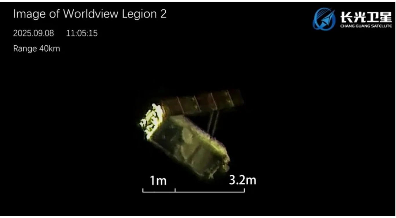
27–28 October 2026: Russia raised the average altitude (SMA) of Object C (64627), the Nivelir-class sub-satellite released by Cosmos 2558 in June 2025, by ~6.1 km (453.0 → 459.2 km). The burn also re-circularized the orbit, dropping eccentricity from 0.00126 to 0.00039. It is Object C’s sixth stationkeeping reboost since July 2025, and each one has followed the same script: let the orbit decay to ~453 km, then climb back to ~459 km. Meanwhile, its parent is gone. Cosmos 2558 (53323), which stopped orbit maintenance in April 2025, reentered on 12 September 2026.
The Latest Maneuver
- Timing: Between the 27 Oct 0707Z and 28 Oct 1731Z.
- Change: SMA +6.1 km (453.0 → 459.2 km); eccentricity 0.00126 → 0.00039.
- Cost: ~3.4 m/s, in same range as the previous five reboosts (3.3–3.6 m/s each).
- Cadence: The interval between reboosts has stretched from 63–78 days in late 2025 to 101 days (Feb–Jun 2026) and now 145 days (Jun–Oct 2026). Object C’s decay rate fell from ~0.08–0.10 km/day to ~0.04 km/day, consistent with lower atmospheric drag…likely due to a decline in the solar cycle.
Object C vs. USA 326
Unfortunately there is a paucity of orbital data for USA 326 (51445). The most recent orbital data we have is a single TLE from 31 Aug 2026 2254Z. Here is a comparison with Object C’s orbit at that time:
| Parameter (31 Aug 2026) | USA 326 | Object C | Difference |
|---|---|---|---|
| Average altitude (SMA) | 500.6 km | 455.4 km | 45.2 km (USA 326 higher) |
| Inclination | 97.397° | 97.230° | 0.17° |
| RAAN | 338.74° | ~338.43° | 0.31° |
| Eccentricity | 0.00036 | 0.00096 | — |
| Orbital period | 94.6 min | 93.7 min | Object C laps USA 326 every ~6.6 days |
| Angle between orbital planes | — | — | ~0.35° |
The two orbits are nearly co-planar but not identical. A 0.35° plane offset produces at most ~42 km of cross-track separation, while the altitude difference keeps the pair ~45 km apart radially. As a result, the best-case close approach is about 45 km. That matches the 44 km point of closest approach we reported in August 2025, and the ~6.6-day lap time lines up with the roughly weekly close approaches noted in the 20 Jul 2025 Flash. We can’t compute current close-approach times without a full, current element set for USA 326. USA 326 orbital data is not published in the space-trak.org catalog, instead we rely on information from the McCants catalog.
Close Approaches Around the Latest USA 326 TLE
To see what those encounters look like, we propagated a 31 Aug 2026 element set for each satellite ±7.5 days (24 Aug – 8 Sep 2026), covering two full lap cycles, and plotted Object C’s position relative to USA 326 in radial, in-track and cross-track (RIC) components.
| # | Closest approach (UTC) | Range | R / I / C (km) | Lighting at closest approach | Best sunlit look |
|---|---|---|---|---|---|
| 1 | 28 Aug 2026 23:57 | 53 km | −45 / +15 / +24 | Both in Earth’s shadow (26°N, | 00:06Z, 68 km, as both exit shadow |
| 2 | 4 Sep 2026 15:02 | 60 km | −50 / −10 / +32 | Both entered shadow ~1 min | ~15:00Z, ~60 km, at closest |
Both encounters as close as 53–60 km, consistent with the 44–58 km closest approaches we reported in summer 2025. Most of the separation is altitude; the remainder is in-track timing and the cross-track offset from the small plane difference. Neither closest approach occurred in sunlight. Both fell right at the edge of Earth’s shadow.
Caveat: These results come from a single TLE for each satellite. We expect some inaccuracies: timing errors of a minute or two and range errors of a few kilometers near the TLE epoch, growing with time. Encounter #2 is ~3.7 days past both epochs, and a small timing error could shift its closest approach to either side of the shadow boundary. Any USA 326 maneuver after 31 Aug would invalidate the prediction entirely. Treat the geometry as representative, not definitive.
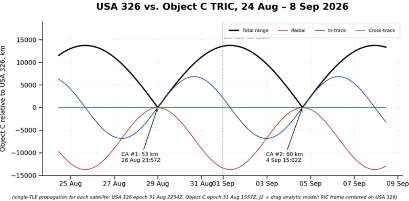
Object C position relative to USA 326 (RIC frame), 24 Aug – 8 Sep 2026. Two closest approaches, ~6.6 days apart. (single-TLE propagation of 31 Aug 2026 element sets for each satellite; based on data from space-track.org)
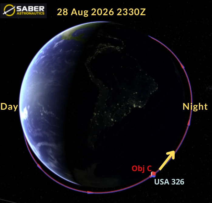
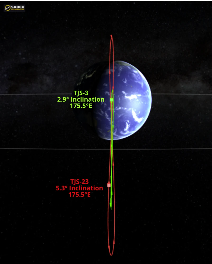
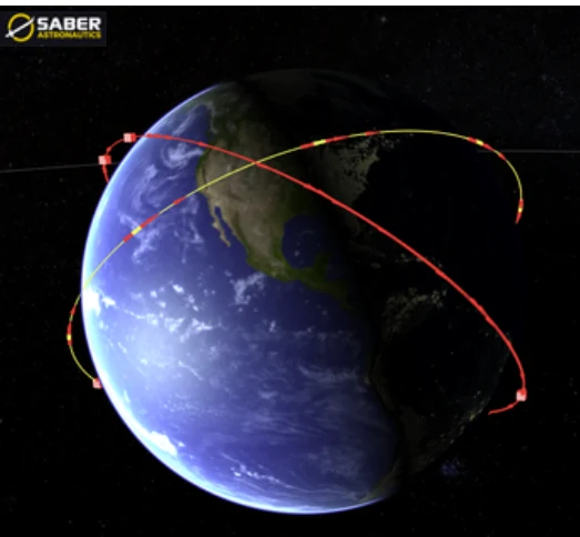
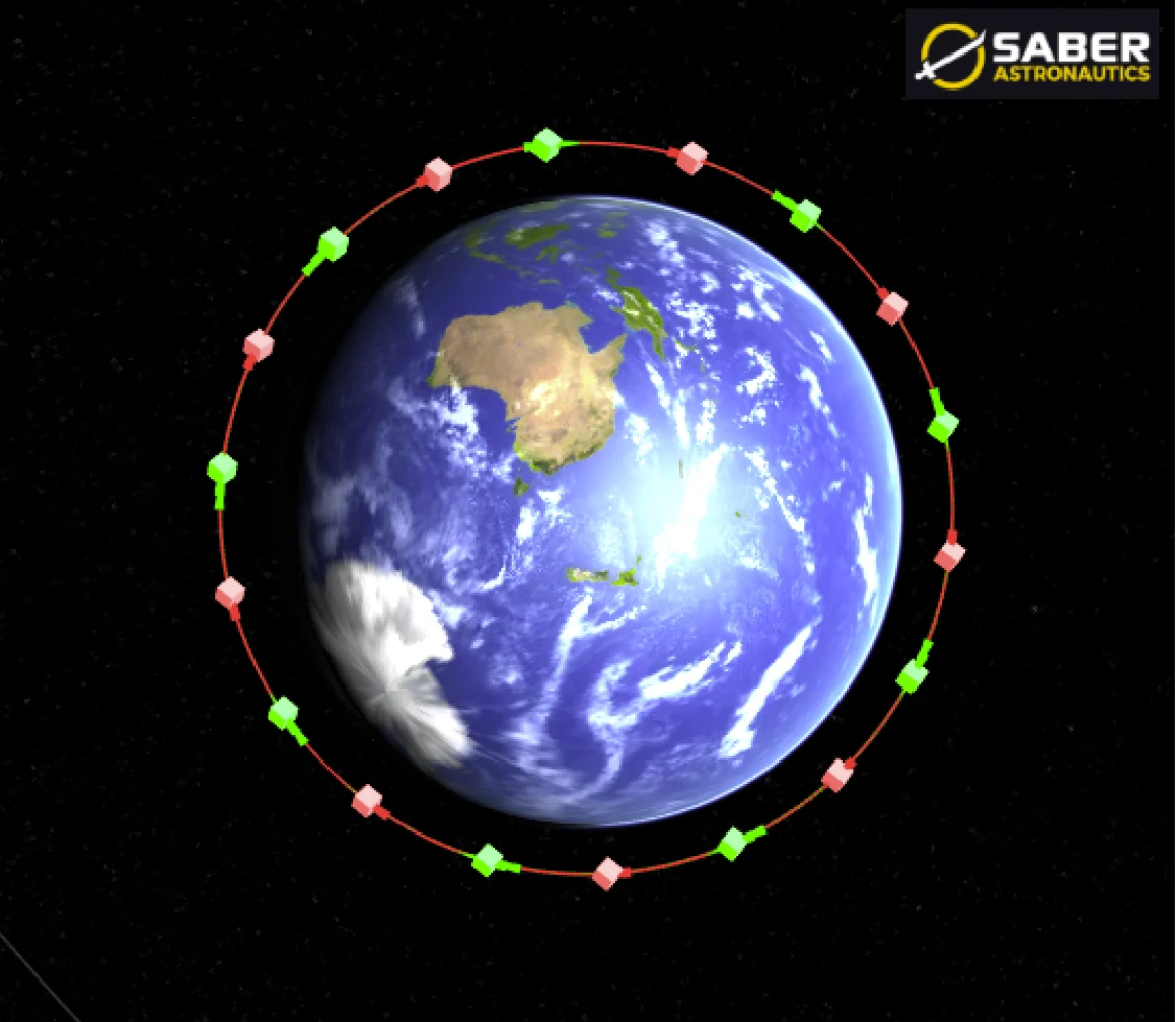
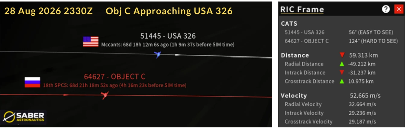
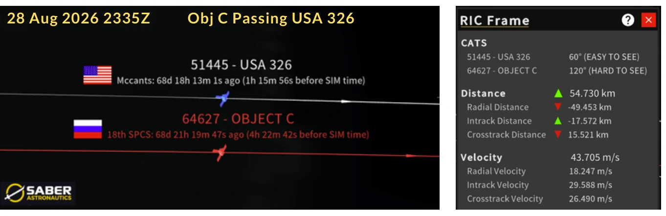
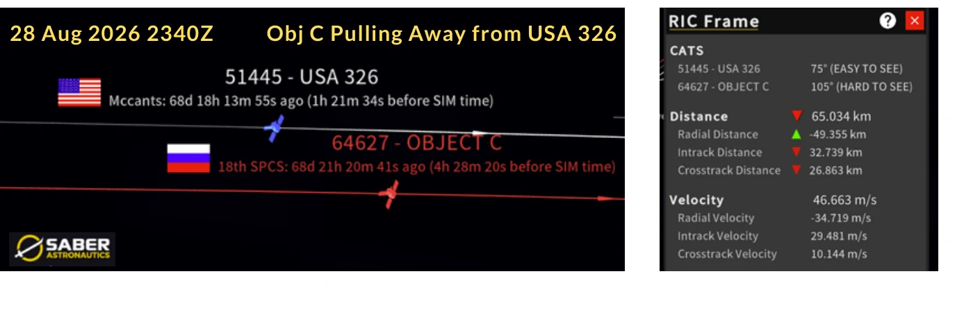
Every 6-7 days Object C passes USA 326. This is done without maneuver and is a function of Object C maintaining a slightly lower (but carefully plane matched) orbit with USA 326. Images depict close approach which occurred on 28 Aug 2026. Close approach happened during orbit “night” so the sun is not illuminating either object. (saberastro.com)
Is Russia Holding Object C in USA 326’s Plane?
It sure seems so, but difficult to be certain due to a lack of current orbital data on USA 326. However, there is strong circumstantial evidence to support a purposeful placement.
Both satellites are in sun-synchronous orbits (normal for imagery satellites), so Earth’s equatorial bulge rotates each orbital plane (its RAAN) about 1° per day. That rotation rate (also known as the J2 effect) depends on two things: altitude and inclination. To stay co-planar, two satellites don’t be at the same altitude or the same inclination. They need the same rate. USA 326 is 45 km higher, which slows its RAAN rotation, and 0.17° more inclined, which speeds it up. The two effects nearly cancel.
That means for Object C’s inclination there is one altitude that keeps its plane turning in step with USA 326’s. Using a J2 model with USA 326’s 31 Aug elements, that altitude is ~456.5 km. Object C’s mean altitude since July 2025 is 456.3 km. Russia’s 453–459 km stationkeeping band is centered almost exactly on the plane-matching altitude.
Two cautions: the result relies on a single USA 326 TLE, and it assumes USA 326 holds its own orbit (as a reconnaissance satellite almost certainly does). The model is accurate to roughly ±1.5 km. Even so, a sub-km match is hard to explain as coincidence. Any satellite has to reboost against drag, but Russia picked this particular altitude to reboost around.
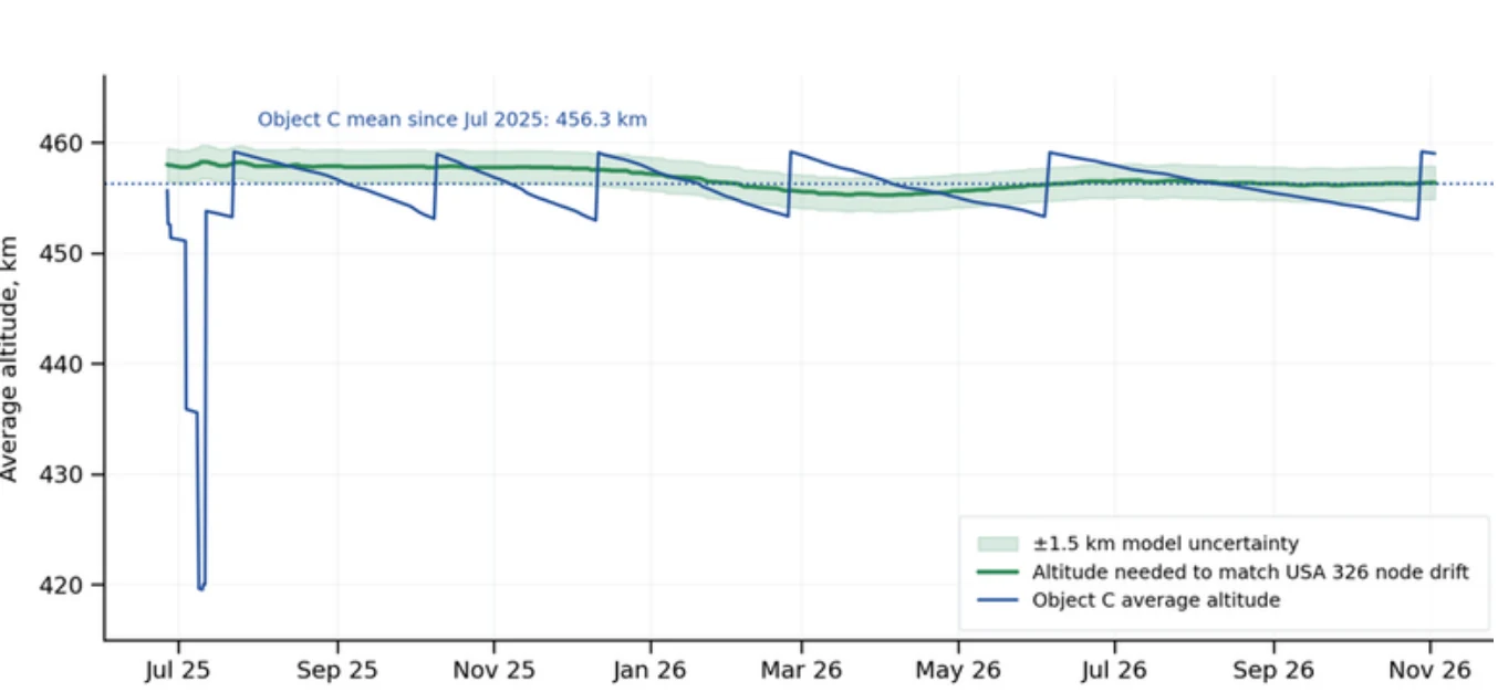
Object C average altitude (blue) vs. the altitude required to match USA 326’s nodal precession (green). Object C’s stationkeeping band is centered on the plane-matching altitude. (based on data from Celestrak.org)
Cosmos 2558: Gone
Cosmos 2558 reentered on 12 Sep 2026, about 17 months after its last orbit-maintenance burn. Through early 2025 Russia flew Cosmos 2558 in a ~459–466 km band, reboosting ~5–6 km every four to six weeks. Its last maneuvers, between 7 and 13 April 2025, were a string of small raises of only 0.25–0.7 km each. After that it stopped maneuvering. We assess the weak final burns may indicate degraded propulsion or propellant depletion. Eleven weeks later, on 26 Jun 2025, Object C separated at ~452 km.
Cosmos 2558 then decayed steadily: it was down to ~300 km by early August 2026 and ~158 km on its final element set (12 Sep 0147Z). The decay also changed its plane. Lower satellites precess faster, so Cosmos 2558’s RAAN pulled away from Object C’s (and USA 326’s), reaching ~15° by reentry. That is what Object C would face without stationkeeping, and it shows why the reboosts matter.
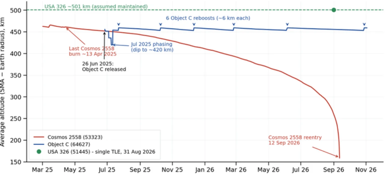
Mar 2025 – Nov 2026: Average altitude of Cosmos 2558 (red) and Object C (blue), with USA 326 (green…and based solely on its 31 Aug 2026 TLE.) (based on data from celestrak.org)
Gas Rationing? Object C Δv Estimate
Using the change in SMA and eccentricity across each maneuver, and assuming efficient in-plane (along-track) burns, we estimate Object C has used roughly 58–80 m/s of Δv since release:
| Activity | Dates | Maneuvers | Est. Δv (m/s) |
|---|---|---|---|
| Phasing campaign (lower to ~420 km, raise to ~454 km) | 27 Jun – 11 Jul 2025 | 5 | 37 – 58 |
| Stationkeeping reboosts (~6 km each) | 22 Jul 2025 – 28 Oct 2026 | 6 | ~20.5 |
| Total since release | 11–12 | ~58 – 80 |
The range in the phasing estimate comes from 10–11 July 2025. Element sets show a large eccentricity change on 10 July followed by a ~34 km raise on 11 July. Treated as one optimized sequence, it costs ~19 m/s; treated as two separate maneuvers, ~39 m/s. Either way, the July 2025 phasing campaign was the largest single expense, at roughly two to three times what Object C has spent on all of its stationkeeping since. These are minimum-impulse estimates.
Looking ahead: Object C’s orbit decays ~0.04 km/day, or ~15 km/year, to hold the 453–459 km band will cost only about 8–9 m/s per year, and more if solar activity picks up. We don’t know how much propellant Object C carried, so we can’t estimate how much remains. Still, a 3.4 m/s burn this October suggests Russia sees no reason to economize yet.
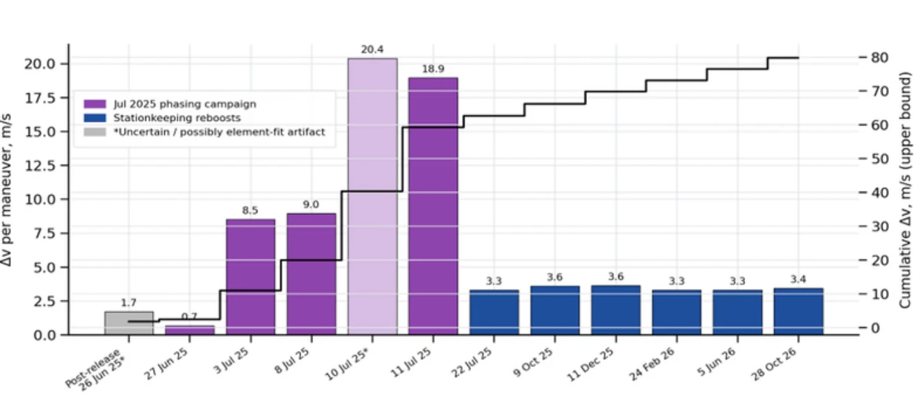
Estimated Δv for each Object C maneuver (bars) and cumulative upper-bound total (line)
Editor’s Comment: Object C’s behavior is consistent with a deliberate handoff with Cosmos 2558. As Cosmos 2558 stopped maneuvering, its sub-satellite took over the job of staying in USA 326’s plane, and it has done so with regular, low-cost reboosts for over 15 months. The altitude band Russia chose matches the altitude needed to keep Object C’s plane turning with USA 326’s. That is strong circumstantial evidence the co-planar relationship is the point. What we can’t confirm is USA 326’s own orbit since 31 August; if USA 326 maneuvers, we would expect Object C to respond.